
Walk a Saratoga County Street Directory
The reliable street-by-street sequence starts with the county parcel key. PROS can identify a property location, current owner, current owner mailing address, class, assessment, and SBL. The county map viewer then supplies the spatial check: confirm the road, click the parcel, and compare nearby boundaries. After that, SearchIQS turns a recorded owner or legal description into a deed trail. This process connects a street address to public record systems without claiming that property ownership proves present residence.
Saratoga County has city, town, village, rural, and postal layers. A road can cross municipality, school, fire, or election-district lines, so use the PROS municipality field and the mapped parcel before choosing a local office. A Saratoga Springs address may also need the City Assessor or City Engineer, while a different town needs its local assessor or building office. Keep the property location, tax-roll mailing address, and legal description as separate facts.
- Enter the street number and name in PROS Quick Search. If needed, use Street Finder, an alternate suffix, or the SBL.
- Record the property location, municipality, owner field, and SBL. Do not treat the tax-roll mailing address as the situs.
- Use the County Online Map Viewer to browse the road and click the selected parcel and adjoining parcels.
- Search the recorded owner in SearchIQS Party 1, last name first without a comma, and preserve the legal description with the purchase deed.
- For a past occupant, ask the Saratoga Room or NYS Library for a relevant street or reverse-directory section, then check a census year or map.
Search a Saratoga County Street Directory in PROS
PROS is the most direct public address tool for a Saratoga County street search. Quick Search accepts Street Address, Tax Map #/SBL, Owner Name, and Street Finder. The county’s instruction example says “5 Pine” can return “5 Pine Street.” Owner Name expects Last, First, while Street Finder supplies a dropdown of street values. Advanced Search adds sale dates, municipality, neighborhood, account number, building area and year, sale price, assessed values, style, bedrooms, bathrooms, condition, basement, and waterfront fields.
Use filters to narrow the right parcel, not to turn the property system into a household list. The resulting roll can show a current owner name and owner mailing address, property location and class, school district, parcel size, assessments, exemptions, special districts, and account number. A sale price can confirm a transaction context, but it does not prove who occupies a property. County guidance places map details under the PROS Notes tab.
| PROS search field | Street-research use |
|---|---|
| Street Address | Find one numbered property, allowing an alternate street suffix. |
| Street Finder | Select a road when a number is unknown or needs checking. |
| Tax Map # / SBL | Reconnect a mapped parcel with its roll record. |
| Owner Name | Move from a recorded owner to the parcel record. |
| Municipality | Separate similarly named places across county jurisdictions. |
The county PROS quick-search page presents the address and owner entry choices described above. The form is a useful first move from a street number to a document-ready parcel identifier.
Saratoga County Street Number Clues
Older and current address trails do not always use a uniform grid. In Saratoga Springs, the City Engineer is the official custodian of the building-number system. Chapter 201, adopted in 2006 and amended in 2018, assigns numbering and street ranges through Public Works and requires notice to owners, USPS, county emergency services, and other agencies. The official street list records sides of streets, skipped numbers, half numbers, and “fudge” ranges.
This local numbering record is an address-continuity tool. For an older directory entry, compare the street name, nearby cross streets, historic district context, map, owner, lot or legal description, and current SBL. Saratoga Springs’ 1915 village and town consolidation can also change the place label in an older source. Do not assume a modern house number alone will find an earlier deed or directory entry.
- Parcel
- A defined tract of land identified in tax and map records.
- Situs address
- The physical property location, which can differ from an owner’s mailing address.
- Plat
- A recorded map of lots or a subdivision used to connect legal descriptions to ground locations.
- Criss-cross directory
- A reverse arrangement that can lead from an address to an occupant in volumes that include it.
Note: A street number may need a municipal, historic-map, and legal-description check before it can be carried across years.
Saratoga County Street Records
Address-keyed records form a chain rather than one master Saratoga County street list. PROS and the tax roll identify a parcel. GIS provides the spatial context. SearchIQS records a land-document party and legal description. Municipal permit files can date construction or a change in occupancy. Historical directories and maps can place a household at a street address in a particular period. Each source has a different keeper and access route.
| Address record | Custodian | Street signal | Access path |
|---|---|---|---|
| PROS parcel record | County Real Property Tax Service | Owner, mailing address, situs, assessment, and SBL | Public portal and local assessor fallback |
| County GIS | County Planning/GIS | Parcel boundaries, adjoining parcels, districts, and map context | Public viewer; exact tool labels can change |
| Deed or mortgage | County Clerk/SearchIQS | Grantor, grantee, legal description, recording trail | Free account, public terminal, $0.50 per printed deed page |
| Tax roll | County and municipality | Owner, SBL, class, district, values, and exemptions | 2023–2026 posted roll PDFs and local assessor |
| Permit, CO, or violation | City or town building office | Construction, inspection, or occupancy chronology | Saratoga Springs FOIL; other municipalities locally |
The SBL and legal description carry the chain more reliably than the street wording. A street name changes, a rural route uses a different postal locality, or a deed uses an estate or corporation as a party. The Saratoga County resident lookup process is better when the question shifts from one street to confirming one named person across records.
Saratoga County Street Map Checks
The County Online Map Viewer is the street-context step between PROS and a land document. The County Historian links it as a searchable tax-parcel map, and county GIS work also supports E-911, election districts and polling sites, environmental planning, farmland and open-space planning, trail mapping, and related geographic work. For an address question, center the road, click the intended parcel, note its SBL and municipality, then compare the adjoining parcels rather than assuming a postal block equals a legal block.
The current public viewer’s exact layer, select, buffer, measure, and result-card labels were not captured in the research. Use the documented action, browse and click parcels, then validate each selected SBL in PROS. That avoids promising a map export or radius function that may not be exposed in the public interface. County GIS is a spatial check; PROS and the County Clerk remain the record custodians for assessment and deed details.
Saratoga County Street Deed Chains
SearchIQS holds the ownership-history layer, but it does not advertise a simple street-address search. Begin with the current owner and SBL from PROS. In the County Clerk index, enter the owner in Party 1 as last name first with no comma. Open the purchase deed through View, copy the grantor, grantee, recording date, document or instrument reference, legal description, and image or book/page location. Search the seller as an earlier grantee and repeat.
Land records are stated to reach back to 1791. That is the county system’s verified historical floor, not a promise that every early document is equally searchable by text. Search spelling variants, initials, spouses, trustees, estates, corporations, mortgage parties, and old town references when a name trail fails. The Clerk’s public terminals and research counter are the documented fallback for a confusing image or an index gap.
The Clerk’s SearchIQS instructions show the Party 1 format and document-view controls.
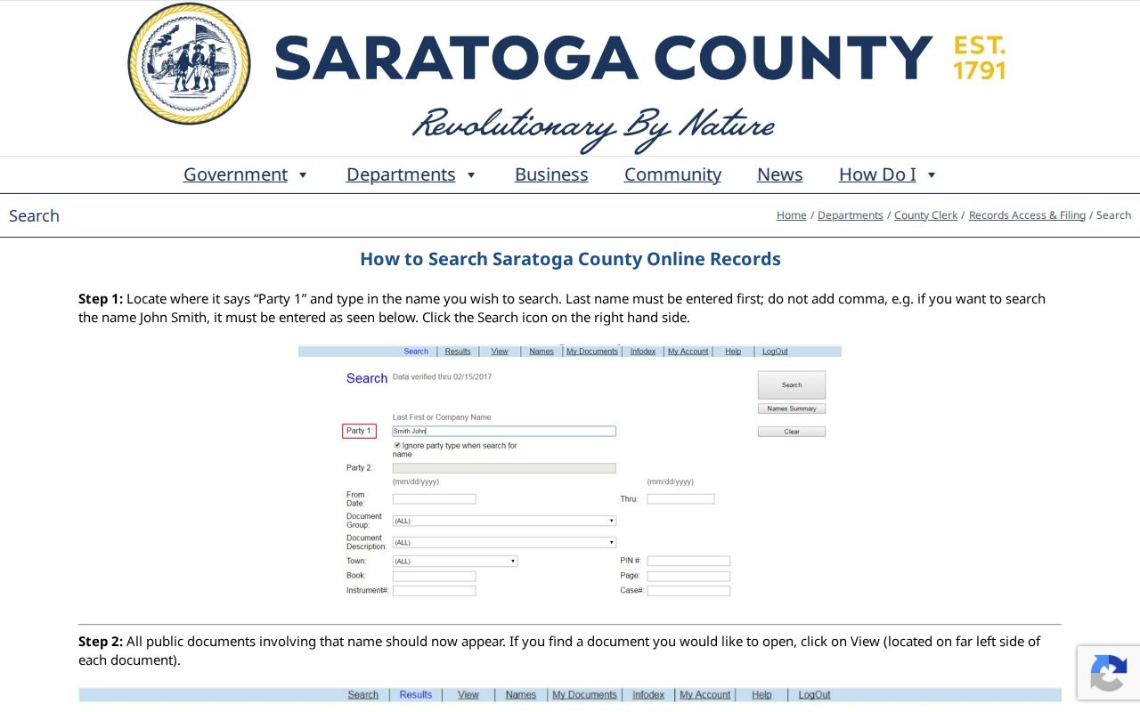
The image page navigation and zoom controls are especially useful where an address-search lead must be checked against an original land document.
Saratoga County Street Search Limits
Voter records do not create an open Saratoga County street-based list. The NYS lookup requires a known registered voter’s last name, first name, date of birth, county, and address or ZIP information. It has no public browse-by-street mode. Election Law §3-220 permits supervised public inspection with sensitive identifiers withheld, while §3-103(5) limits voter-derived information to an elections purpose. Confidential registrations under §5-508 remain separated from ordinary inspection.
Permit and code material has a separate local path. Saratoga Springs Building Department handles construction, alteration, repair, plumbing, signs, pools, decks, and occupancy-related work. Its page provides application-status and counter procedures but directs requests for certificates of occupancy, permits, and violations to a city FOIL request. Other county towns and villages hold their own building files. A permit can date building work or name an applicant; it is not a resident roll.
Saratoga County Street History Clues
Saratoga Springs historic-district information can add useful context when an address falls near an older street pattern. The city identifies Union Avenue, Eastside, Congress Park, Hillside, Broadway, North Broadway, and Franklin Square as separate historic areas with named streets and boundaries. These labels help compare an old directory number with a period map, photograph, or building record. They are context clues, not legal parcel boundaries and not a substitute for the current GIS parcel.
The 1915 city consolidation and the modern numbering record reinforce the same lesson. A street name may persist while the municipal label, number range, or description changes. Match an historic district street cluster with the street’s cross roads, parcel description, and a dated map. The 1895 Library of Congress Sanborn set is a free building-context source, while City Engineer and municipal records provide the current addressing authority.
Saratoga County Street Address History
For prior occupants, reverse or criss-cross directory material is the address-to-name layer. Saratoga Room and regional-library references document this type of material, but the exact local run was not verified. Ask library staff or check the catalog for the year needed, then use the street or reverse-address section only where the volume provides it. Saratoga Springs directories begin locally in 1868, with New York State Library film for 1872–1944 and 1946, plus selected telephone-book runs.
Copy an entry exactly, including initials, apartment or unit, street spelling, and the volume’s abbreviations. Then compare an alphabetical directory entry with a census year, a Sanborn map, or a deed. The 1895 Saratoga Sanborn set has 30 sheets and can show a building footprint, materials, and use. It cannot name every occupant. The current street trail and historical house trail are related but they answer different date-specific questions.
Note: A directory entry supports a dated address clue; it does not establish current residence, ownership, or every person in a household.
What Saratoga County Street Records Miss
Public address records do not reveal a universal list of renters, household members, utility customers, mail recipients, or delivery records. A tax mailing address may be outside Saratoga County and does not establish that an owner lives at the parcel. DMV personal information is restricted under the federal Driver’s Privacy Protection Act. New York’s Address Confidentiality Program and confidential voter registration deliberately break ordinary address trails.
Check the custodian. A missing street result may reflect a protected record, a different municipality, a surname variant, or an unindexed source. The holding office decides what can be released.